
Republished courtesy of
ZenTek Consultants, an Authorized Partner.
Autodesk Civil 3D® has its own field-to-finish solution, but it’s not for everyone.
Generating linework requires the creation of a survey database. The survey database must be centrally located in a team environment. The process of importing survey data into a drawing gets funneled through the database to the drawing. Edits made to points must be applied to the database using the tools on the Survey tab (the third tab on the Civil 3D Toolspace) since points are locked to the observation recorded in the database and cannot be edited using the Panorama in the drawing. To some, the database is a troublesome anchor that hinders production. For those folks, another means of generating linework can be implemented.
Stringer Topo, a lightweight add-on tool for Autodesk Civil 3D, will generate linework without the need for a survey database or figure prefixes.
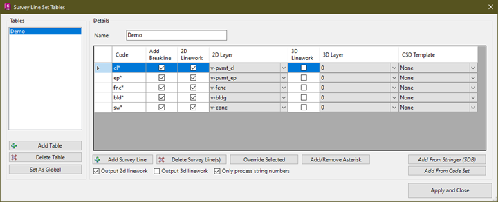
As a matter of fact, instead of figures, you get polylines. In the dialog pictured below, multiple code sets can be configured depending on client needs. Basically, any code appearing in this table generates a polyline. Similar linear features can be differentiated by adding a number to the end of the code, as with opposite edges of pavement. No begin or end codes are needed. Each code can be configured to be a break line or not. You also have the choice of generating a 2D or 3D polyline or both. If generating both, note that you can configure 2D to go on a different layer than 3D.
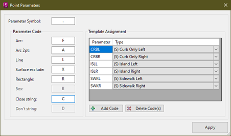
As mentioned, any code appearing in the Survey Line Set will generate linework, but when curves are needed, two triggers are available. In the dialog below, if .F is entered after the description in the survey instrument, it will kick off a 3 point curb using the current point as the first point of that curb. If .A is entered, a two point curb will be generated using the current point as the PC and the next as the PT creating a tangent curb at the incoming and outgoing segments. The curve mode repeats for either curve type until another point with the same description is collected using the .L option, putting the draw mode in line mode. The codes in this dialog are customizable.
Point files are imported via the Import Points tool on the Insert ribbon. Stringer Topo will recognize the linework parameters in the descriptions of the imported points and will generate polylines, thus “stringing” the points together. No need to struggle with the restrictions of the Civil 3D survey database. Corrections on collected points can be made directly in the Edit Points tab of the Panorama, thereby simplifying the Civil 3D field to finish workflow.
TEK Bloks | Prepaid Support When You Need It
Use TEK Bloks prepaid support from ZenTek Consultants when you need help with Civil Site Design questions, problems, workflows, and standards.